ABOUT KEDAH HISTORY

Recorded history shows that in the 5th century AD, traders plying the east-west trade route stopped at the port of Kuala Muda, using Gunung Jerai, Kedah's highest peak, as a navigational point.

The ruins of ancient Candi (temples) in the Bujang Valley show that a Hindu-Buddhist civilization existed here and may have been one of the first places to have come into contact with Indian traders. How important this kingdom was, is still being researched as more artifacts are unearthed.

During the 7th and 8th centuries, Kedah paid tribute to the Sumatran Srivijaya Empire. After the decline of the empire, it became a vassal state to the Thais until the 15th Century when the rise of Malacca led to the Islamization of the area. Kedah faced Portuguese and Achehnese attacks in the 17th century, but it again fell into Thai hands in 1821.

The Thais handed Kedah over to the British in 1909, and after the Japanese occupation, it became one of the states of the Malayan Union and subsequently the Federation of Malaya in 1948.


All My Friends

SEE AND HEAR MORSE CODE

Tuesday, March 2, 2010

NASA Radar Finds Ice Deposits At Moon's North Pole

Craters at the north pole of the Moon. *Fresh Craters. *Anomalous Craters.

Additional evidence of water activity on moon:
Using data from a NASA radar that flew aboard India's Chandrayaan-1 spacecraft, scientists have detected ice deposits near the moon's north pole. NASA's Mini-SAR instrument, a lightweight, synthetic aperture radar, found more than 40 small craters with water ice. The craters range in size from 1 to 9 miles (2 to15 km) in diameter. Although the total amount of ice depends on its thickness in each crater, it's estimated there could be at least 600 million metric tons of water ice.
The Mini-SAR has imaged many of the permanently shadowed regions that exist at both poles of the Moons. These dark areas are extremely cold and it has been hypothesized that volatile material, including water ice, could be present in quantity here. The main science object of the Mini-SAR experiment is to map and characterize any deposits that exist.
Mini-SAR is a lightweight (less than 10 kg) imaging radar. It uses the polarization properties of reflected radio waves to characterize surface properties. Mini-SAR sends pulses of radar that are left-circular polarized. Typical planetary surfaces reverse the polarization during the reflection of radio waves, so that normal echoes from Mini-SAR are right circular polarized. The ratio of received power in the same sense transmitted (left circular) to the opposite sense (right circular) is called the circular polarization ratio (CPR). Most of the Moon has low CPR, meaning that the reversal of polarization is the norm, but some targets have high CPR. These include very rough, fresh surfaces (such as a young, fresh crater) and ice, which is transparent to radio energy and multiply scatters the pulses, leading to an enhancement in same sense reflections and hence, high CPR. CPR is not uniquely diagnostic of either roughness or ice; the science team must take into account the environment of the occurrences of high CPR signal to interpret its cause.
Numerous craters near the poles of the Moon have interiors that are in permanent sun shadow. These areas are very cold and water ice is stable there essentially indefinitely. Fresh craters show high degrees of surface roughness (high CPR) both inside and outside the crater rim, caused by sharp rocks and block fields that are distributed over the entire crater area. However, Mini-SAR has found craters near the north pole that have high CPR inside, but not outside their rims. This relation suggests that the high CPR is not caused by roughness, but by some material that is restricted within the interiors of these craters. We interpret this relation as consistent with water ice present in these craters. The ice must be relatively pure and at least a couple of meters thick to give this signature.
The estimated amount of water ice potentially present is comparable to the quantity estimated solely from the previous mission of Lunar Prospector’s neutron data (several hundred million metric tons.) The variation in the estimates between Mini-SAR and the Lunar Prospector’s neutron spectrometer is due to the fact that it only measures to depths of about one-half meter, so it would underestimate the total quantity of water ice present. At least some of the polar ice is mixed with lunar soil and thus, invisible to our radar.
Main L, 14 km diameter, 81.4° N, 22° E

"The emerging picture from the multiple measurements and resulting data of the instruments on lunar missions indicates that water creation, migration, deposition and retention are occurring on the moon," said Paul Spudis, principal investigator of the Mini-SAR experiment at the Lunar and Planetary Institute in Houston. "The new discoveries show the moon is an even more interesting and attractive scientific, exploration and operational destination than people had previously thought."
"After analyzing the data, our science team determined a strong indication of water ice, a finding which will give future missions a new target to further explore and exploit," said Jason Crusan, program executive for the Mini-RF Program for NASA's Space Operations Mission Directorate in Washington.
The Mini-SAR's findings are being published in the journal Geophysical Research Letters. The results are consistent with recent findings of other NASA instruments and add to the growing scientific understanding of the multiple forms of water found on the moon. The agency's Moon Mineralogy Mapper discovered water molecules in the moon's polar regions, while water vapor was detected by NASA's Lunar Crater Observation and Sensing Satellite, or LCROSS.
Mini-SAR and Moon Mineralogy Mapper are two of 11 instruments on the Indian Space Research Organization's Chandrayaan-1. The Applied Physics Laboratory in Laurel, Md., performed the final integration and testing on Mini-SAR. It was developed and built by the Naval Air Warfare Center in China Lake, Calif., and several other commercial and government contributors.

For more information about Chandrayaan-1, visit:
http://www.isro.org/Chandrayaan

GOES-P Launch Now No Earlier than March 4


Image above: Sunrise at Launch Complex 37 on Cape Canaveral Air Force Station finds NASA's GOES-P meteorological satellite newly arrived in this photo taken Feb. 14, 2010. Photo credit: NASA/Jack Pfaller

Final prelaunch preparations continue at Launch Complex 37 on Cape Canaveral Air Force Station in Florida, where a Delta IV rocket is set to launch the GOES-P satellite no earlier than March 4. The launch window extends from 6:17 p.m. to 7:17 p.m. EST.Geostationary Operational Environmental Satellite-P, or GOES-P, is the latest in a series of meteorological satellites designed to watch for storm development and weather conditions on Earth. From its location in Earth orbit, GOES-P's state-of-the-art instrumentation will supply data used in weather monitoring, forecasting and warnings. It also will detect ocean and land temperatures, monitor space weather, relay communications and provide search-and-rescue support.GOES-P, to be launched for NASA and NOAA, is a United Launch Alliance commercial launch for Boeing Launch Services under a Federal Aviation Administration license.

Thursday, February 25, 2010

CELEBRATING THE PROPHET'S BIRTHDAY WITH SPIRIT OF UNITY

By Rohana Mustaffa - Thursday, February 25


KUALA LUMPUR, Feb 25 (Bernama) -- In the narration of a hadith, the Prophet had once said, which means :"Bless those who saw me and believed in me (he said this once) and bless who did not see but believed in me (he said this seven times)".
To the ulama, welcoming the Prophet's birthday or Maulidur Rasul means remembering and having faith in the Prophet that also brings the realisation of Allah's greatness. In the Surah Al-Hajj, Allah has spelt out, the words that carries the meaning:" Anybody who glorifies greatness, it depicts the person's taqwa”. (Taqwá is the Islamic concept of God-consciousness. Taqwa is defined as the state of being conscious of Allah. Avoiding actions that lead to Allah`s anger and disapproval while consciously undertaking steps and actions that will please Allah).

Hence Maulidur Rasul is celebrated with the sense of taqwa be it at any functions including ceramah or forum to bring Muslims closer to appreciating the Prophet's noble values, avoiding what he had disapproved and doing what he pleased as well as inviting others to join his dakwah, among others.

PROPHET'S TEACHINGS

Among the Prophet's teachings is for man to always to do good. Muslims were told to be equally fair to both friends and foes, practise the spirit of brotherhood apart from living peacefully in a community and rendering assistance for the performance of good deeds. The Prophet himself had lived among the infidel Quraish community in Mecca but he, along with those who had embraced Islam, introduced the spirit and sense of brotherhood to the non-Muslim community.
When the Prophet's companions, who were originally infidels who had converted to Islam, the Prophet had never barred them from doing good to their family members who had yet to be Muslims. “Unfortunately, many among us choose to be against each other. As if resolving differences via conflicts is a better way of finding the solution as compared to settling the dispute in an amicable manner," according to the Malaysian Institute of Islamic Understanding (Ikim) Fellow Azrina Sobian. In her article about the disputes that occurred in the Malaysian society recently, she reminded that history had proven that conflicts that were not handled well can give rise to catastrophes.

GREED, SELFISH

She said many among us had placed greed and self-interest apart from having failed or declined to accept the detrimental effects of the differences where such conflicts could have been averted.
Azrina, who is Ikim's Science and Environmental Studies Fellow, wrote that preferring splits over unity is well against the principle of Islam. Islam advocates unity and brotherhood (mentioned in Surah an-Nisaa’ 4:1, Surah al-Hujuraat 49:10) and admonishes disunity (Surah ali-Imran 3:103). Islam calls on us to know and understand each other (Surah al-Hujuraat 49:13) to achieve prosperity in life. “Witness the beauty of what Islam sees in the spirit of brotherhood. Unfortunately at present, the negligence, misunderstanding and refusal to embrace this demand has led us to be involved in disputes rather than being good to one another," she wrote. According to Azrina, if studied closely the reasons behind this, then man would return to the main trait of being greedy. Greed to become rich, to be leaders, greed to get all projects, to become the most popular and all forms of greed to the extent of jeopardising the peace and unity.

CORRECTING THE SITUATION

The key measure to correct the situation is by being aware of the respective facts and responsibility, wrote Azrina. "As members of the community, we have the responsibility to exercise wisdom to specifically weed out the evil elements that can lead us to splits. We need not believe all that reached our ears as what being passed around may not be the truth". Whatever it is, the main objective is to remain united and avoid splits, she wrote. "Have it ever crossed our mind that if we think that our opinion is correct, so are that from the others?" she asked. According to Azrina, this is the principle held by Imam Shafie on the different thinking of other ulama in his time. Imam Shafie had one said:“In God's name, I do not care if the truth is from my own tongue or that of my enemy”. This means that Imam Shafie had wanted to avoid splits and differences that could arise from conflicts of opinion and his main ojective is to preserve unity. This is what is known as 'unity amidst differences'. If each of us uphold this objective and unite, then many issues can be amicably resolved, wrote Azrina. Therefore, seek unity and not splits, as in the words of Al-Subki, the author of biographies on figures in the Shafie Sect.
“Without a conflict, it is a blessing".

-- BERNAMA RON ZUL RON

Wednesday, February 24, 2010

Le Tour de Langkawi

Le Tour de Langkawi
De 20 lagene er klare.

Pressemelding:20 TEAMS CONFIRMED FOR LTDL 2010

THE final list of 20 teams to contest the 15th edition of Le Tour de Langkawi (LTdL) 2010 from March 1 to 7 has been confirmed with American team Kelly Benefit Services completing the line-up yesterday.
Apart from Kelly Benefit Strategies, which is registered in Minneapolis, the Colombian national team and Thailand have been roped in to replace ProTour teams Astana and Caisse d'Epargne who could not make the race, although they were on the initial list of the organisers.
The line-up for LTdL 2010 is led by one ProTour team, Footon-Servetto from Spain, two Professional Continental teams - ISD-Neri (Italy) and Vorarlberg-Corratec (Austria).
The remaining teams are made up of 12 Continental teams - Drapac-Porsche (Australia), Tabriz Petrochemical (Iran), Seoul Cycling Team (South Korea), Marco Polo Cycling Team (China), Aisan Racing Team (Japan), Max Success Sport (China), Le Tua Cycling Team (Malaysia), Team Geumsan Ginseng Asia (South Korea), Team Jayco-Skins (Australia), Azad University (Iran), Giant Asia Racing Team (Taiwan) and Kelly Benefit Strategies (USA).
Five national teams complete the line-up. They are South Africa, Kazakhstan, Colombia, Thailand and Malaysia.
The Colombian national team features the interesting return to LTdL of 2002 overall winner Hernan Dario Munoz, winner of the Genting Highlands stage for two consecutive years in 2002 and 2003 when he was riding for the Colombia-Selle Italia team under charismatic director Gianni Savio.
The Thai national team makes its first appearance in the Tour began in 1996, taking it's turn from the Indonesian and Philippines national teams who had been invited prior to this.
Apart from Kelly Benefit Services, three other Continental teams will be making their debuts in this year's race - Aisan Racing Team, Max Success Sports and Geumsan Ginseng, who will feature Malaysian sprinter Anuar Manan.
TEAM LIST - LTDL 2010

1 FOOTON-SEVETTO PROTOUR (SPAIN)
2 ISD-NERI (ITALY)
3 VORARLBERG-CORRATEC (AUSTRIA)
4 DRAPAC PORSCHE (AUSTRALIA)
5 TABRIZ PETROCHEMICAL (IRAN)
6 SEOUL CYCLING TEAM (SOUTH KOREA)
7 MARCO POLO CYCLING TEAM (CHINA)
8 AISAN RACING TEAM (JAPAN)
9 MAX SUCCESS SPORT (CHINA)
10 LE TUA CYCLING TEAM (MALAYSIA)
11 TEAM GEUMSAN GINSENG ASIA (SOUTH KOREA)
12 TEAM JAYCO- SKINS (AUSTRALIA)
13 AZAD UNIVERSITY (IRAN)
14 GIANT ASIA RACING TEAM (TAIWAN)
15 KELLY BENEFIT STRATEGIES (USA)
16 SOUTH AFRICA NATIONAL TEAM
17 KAZAKHSTAN NATIONAL TEAM
18 MALAYSIA NATIONAL TEAM
19 COLOMBIA NATIONAL TEAM
20 THAILAND NATIONAL TEAM

The 15th edition of the UCI (Hors Category) stage race will take place from Kota Bharu - Kuala Berang (174.5km); Kuala Terengganu - Chukai (182.3km); Pekan - Mersing (145.6km); Mersin-Parit Sulong (163.5km); Muar - Port Dickson (111.5km) Putrajaya - Genting Highlands (102.8km) and Kuala Kubu Baru - Dataran Merdeka (133.7km), covering a total distance of 1013.9km. A total of 120 riders from 20 teams including two local teams are expected to take part in the event, Le Tour de Langkawi 2010.

Tuesday, February 23, 2010

CryoSat Satellite Scheduled to launch February 25th, 2010 - Satellite Imaging News

GLOBAL WARMING PR NEWS

ESA's CryoSat the most sophisticated satellite ever to investigate the Earth's ice fields and map ice thickness over water and land
HOUSTON, TX, February 20, 2010 /Global Warming PR News/ -- ESA's CryoSat the most sophisticated satellite ever to investigate the Earth's ice fields and map ice thickness over water and land is scheduled to launch February 25, 2010 at 14:57 CET (13:57 UTC). The launcher is operated by the international space company Kosmotras. Its primary objective is to test the prediction that Arctic sea ice is thinning due to global warming.To read full story and view images visit here http://news.satimagingcorp.com/2010/02/1391.html#The CryoSat satellite sensor whose name comes from the Greek kruos meaning icy cold - carries the first all-weather microwave radar altimeter. The instrument has been optimized for determining changes in the thickness of both floating sea ice, which can be up to several meters, and polar land ice sheets, which in Antarctica can be up to five kilometers. The mission will deliver data on the rate of change of the ice thickness accurate to within one centimeter.Data from CryoSat will lead to a better understanding of the dynamics of ice mass, provide the scientific community with valuable information on this variable and contribute to climate change studies.CryoSat will also survey the surface of continental ice sheets to detect small elevation changes. CryoSat's high spatial resolution radar altimeter is capable of operating in a number of modes, optimized for measurement over different surfaces.For some years, satellites such as Envisat, ASTER and Landsat 7 +ETM have been mapping the extent of ice cover. However, in order to understand how climate change is affecting these sensitive regions, there is an urgent need to determine how the thickness of the ice is changing.Satellite image data is expected to contribute to a wide array of global change-related application areas for vegetation and ecosystem dynamics, hazard monitoring, geology and soil analysis, land surface climatology, hydrology, land cover change, and the generation of orthorectified digital elevation models (DEMs).In addition to changes in the atmosphere's composition, changes in the land surface can have important effects on climate. For example, land change can affect temperature by changing how much solar radiation the land reflects and absorbs. Processes such as deforestation, reforestation, desertification and urbanization often contribute to changes (including temperature, wind and precipitation) in the places they occur. These effects may be significant regionally, but reduced when averaged over the entire globe.With regard to studies about the Earth's cryosphere, high resolution satellite sensors such as the GeoEye-1 at 0.41m resolution, WorldView-2 at 0.46m, Worldview-1, QuickBird, and IKONOS, these sensors will be an important tool for tracking changes in the Arctic and elsewhere.About Satellite Imaging Corporation:Satellite Imaging Corporation (SIC), a privately held technology company that provides high resolution satellite imagery from satellite sensors such as GeoEye-1, WorldView-2 Worldview-1, QuickBird, IKONOS, SPOT-5 and other remote sensing products for analysis and mapping applications such as Geographic Information System (GIS).The company specializes in mono and stereo satellite imaging technology producing seamless orthorectified satellite imaging mosaics DEM's and 3D terrain models for many industries using CAD and GIS applications including engineering and construction, homeland security, defense, intelligence and disaster response using high and medium resolution mono and stereo satellite image data.
For more information contact:
Satellite Imaging Corporation
12777 Jones Road, Suite 370Houston,
Texas 77070-4671U.S.A.

Shuttle Endeavour back safely from space

Sun Feb 21, 10:23 pm ET
CAPE CANAVERAL, Florida (Reuters) � Space shuttle Endeavour landed safely in Florida on Sunday, ending a 14-day mission to the International Space Station.
Endeavour and its six-member crew glided onto the runway at the Kennedy Space Center at 10:20 p.m. EST, after double-sonic booms signaled the spaceship had dropped beneath the sound barrier for first time since its predawn blastoff on February 8.
(Reporting by Irene Klotz; Editing by Tom Brown)

NASA image shows the space shuttle Endeavour shot from the International Space Station (ISS). Endeavour undocked from the ISS after completing a nine-day mission, which consisted in delivering a module dubbed Tranquility.(AFP/NASA/File)

The space shuttle Endeavour returns to the Kennedy Space Center in Cape Canaveral, Florida, February 21, 2010.REUTERS/Craig Rubadoux/Pool

The space shuttle Endeavour lands at the Kennedy Space Center in Cape Canaveral, Florida. After finding a break in the rainy weather at two US landing sites, Endeavour descended to a landing in Florida to end a two-week mission that pushed the long running assembly of the International Space Station close to completion.(AFP/Jim Watson)
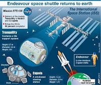
Fact file on US space shuttle Endeavour's mission to install a new model at the International Space Station. After finding a break in the rainy weather at two US landing sites, Endeavour descended to a landing in Florida to end a two-week mission that pushed the long running assembly of the International Space Station close to completion.(AFP/Graphic)

More Go To : http://news.yahoo.com/s/nm/20100222/sc_nm/us_space_shuttle_146

Special Tnx to YC5NBX for the infomations about Messages From Earth "SAIL AWAY" with LIGHTSAIL and IKAROS and "GO TO MARS" - send your name to MARS.

Go To MARS

Participation Certificate GO TO MARS

Artist Concept of the Mars Science Laboratory Rover

Our name will be included with others on a Microchip on the Mars Science Laboratory Rover heading to MARS in 2011.

Sunday, February 21, 2010

"SAIL AWAY"


Participation Certificate "SAIL AWAY" With LIGHTSAIL And IKAROS

Two pioneering missions are preparing to set sail and you can be aboard!

Lightsail, a project of The Planetary Society, will merge the ultra-light technology of nanosats with the ultra-large technology of solar sails setting a course to the stars. LightSail-1 is the beginning of an innovative program that will launch three separate spacecraft over the course of several years.

IKAROS (Interplanetary Kite-craft Accelerated by Radiation Of the Sun) is a solar sail which gathers sunlight as propulsion by means of a large sail. This solar powered sail craft will employ both photon propulsion and thin film solar power generation during its interplanetary cruise. IKAROS will be launched together with the Venus Climate Orbiter, 'Akatsuki' in fiscal 2010 by JAXA.

MyEQSLCard

MyEQSLCard

eQSL Card (Recieved)

eQSL Card (Recieved)

igq107 QSL Card

igq107 QSL Card


THE POSTCARD CROSSING PROJECT

THE POSTCARD CROSSING PROJECT
“send a postcard and receive a postcard back from a random person somewhere in the world!”

ABOUT AMATEUR RADIO

Amateur radio service is defined in the Communication and Multimedia (Spectrum) Regulations 2000 as a radiocommunications service (covering both terrestrial and satellite) in which a station is used for the purpose of self traning, intercommunication and technical investigations carried out by authorized persons who are interested in radio technique solely with a personal aim and without any pecuniary interest.

AMATEUR RADIO OPERATOR'S CERTIFICATE

Regulation 27(1) of the Communications and Multimedia (Technical Standards) Regulations 2000 states that no person shall undertake or conduct any activity in designated skil area unless that person is certified. Amateur radio operator has been gazetted as a designated skill area category under the regulation, hence to operate an amateur radio station a person needs to have an appropriate proficiency and skill i.e. certified in this area.

INTERFERENCE

Please ensure that the radio transmision does not cause interference to any other radio services. Regulation 15(1) of the Communications and Multemedia (Technical Standards) Regulations 2000 states that no person shall intentionally design, install, operate, maintain or modify any communications equipment in a manner is likely to cause interference with, impairment, mulfunction of, or harm to any communications equipment or any other equipment.

Regulation 15(2) of the regulation denotes that a person who contravenes this regulation commits an offence and shall, on conviction, be liable to a fine not exceeding three hundred thousand ringgit (RM 300,000.00) or to imprisonment for a term of not exceeding three years or to both.

To eliminate the potential of interferences, the following procedures must be followed strictly:-

a) Ensure that suffient equipment, tools and test gear is available and can used to monitor and verify that your transmission does not cause any interference to other radio services.

b) You must responsible if your amateur radio is found to be the caused of interference. Immediate remedy action must be taken to rectify the problems in case of interference.

c) Ensure that the transmission do not exceed the level of over deviation.

d) Ensure that the radiated energy is always within the narrowest posible frequency bands for any class of emission in use.

e) The radiation of harmonics and spurious emissions should be suppressed to minimize interference.

Historical Description of Amateur Radio: From the Encyclopedia Britannica:-

Interest in amateur radio arose around the turn of the century, shortly after the Italian inventor Guglielmo Marconi successfully sent the first transatlantic wireless signal in 1901. The interference of amateur broadcasts with commercial and military transmissions led to the institution of government control in 1911. After World War I, amateurs became active in radio experimentation, contributing to developments in long-distance broadcasting and becoming the first radio operators successfully to exploit the upper medium-frequency and lower high-frequency radio bands. Over the years, amateur radio operators have also provided emergency communications during forest fires, floods, hurricanes, and other disasters. They serve as an important link between stricken communities and the outside world until normal communications are reestablished.Amateur radio operators in the United States are subject to international and federal regulations. There are five classes of licenses. Competence in the use of the International Morse Code and a knowledge of radio theory and regulation are required to obtain the advanced-level licenses. Amateur radio is allocated frequencies at the extreme high-frequency end of the medium-wave band, five groups of frequencies in the shortwave band, two groups in the veryhigh-frequency band, three in the ultrahigh-frequency band, and seven in the superhigh-frequency band for telegraphic and telephonic communication using amplitude and frequency modulation. There are restrictions on the power of the transmitters, and certain of the frequencies must be shared with due regard for the needs of other users.

MyBlogLog

DIY Printed circuit board

How To Make A PCB

ROGER BEEP ISD1420

ROGER BEEP

ROGER BEEP ALL RADIO

FOX TX with MP3 PLAYER Function as CWID'er (YC5NBX)