
 GLOBAL WARMING PR NEWS
ESA's CryoSat the most sophisticated satellite ever to investigate the Earth's ice fields and map ice thickness over water and land
HOUSTON, TX, February 20, 2010 /Global Warming PR News/ -- ESA's CryoSat the most sophisticated satellite ever to investigate the Earth's ice fields and map ice thickness over water and land is scheduled to launch February 25, 2010 at 14:57 CET (13:57 UTC). The launcher is operated by the international space company Kosmotras. Its primary objective is to test the prediction that Arctic sea ice is thinning due to global warming.To read full story and view images visit here
http://news.satimagingcorp.com/2010/02/1391.html#The CryoSat satellite sensor whose name comes from the Greek kruos meaning icy cold - carries the first all-weather microwave radar altimeter. The instrument has been optimized for determining changes in the thickness of both floating sea ice, which can be up to several meters, and polar land ice sheets, which in Antarctica can be up to five kilometers. The mission will deliver data on the rate of change of the ice thickness accurate to within one centimeter.Data from CryoSat will lead to a better understanding of the dynamics of ice mass, provide the scientific community with valuable information on this variable and contribute to climate change studies.CryoSat will also survey the surface of continental ice sheets to detect small elevation changes. CryoSat's high spatial resolution radar altimeter is capable of operating in a number of modes, optimized for measurement over different surfaces.For some years, satellites such as Envisat, ASTER and Landsat 7 +ETM have been mapping the extent of ice cover. However, in order to understand how climate change is affecting these sensitive regions, there is an urgent need to determine how the thickness of the ice is changing.Satellite image data is expected to contribute to a wide array of global change-related application areas for vegetation and ecosystem dynamics, hazard monitoring, geology and soil analysis, land surface climatology, hydrology, land cover change, and the generation of orthorectified digital elevation models (DEMs).In addition to changes in the atmosphere's composition, changes in the land surface can have important effects on climate. For example, land change can affect temperature by changing how much solar radiation the land reflects and absorbs. Processes such as deforestation, reforestation, desertification and urbanization often contribute to changes (including temperature, wind and precipitation) in the places they occur. These effects may be significant regionally, but reduced when averaged over the entire globe.With regard to studies about the Earth's cryosphere, high resolution satellite sensors such as the GeoEye-1 at 0.41m resolution, WorldView-2 at 0.46m, Worldview-1, QuickBird, and IKONOS, these sensors will be an important tool for tracking changes in the Arctic and elsewhere.About Satellite Imaging Corporation:Satellite Imaging Corporation (SIC), a privately held technology company that provides high resolution satellite imagery from satellite sensors such as GeoEye-1, WorldView-2 Worldview-1, QuickBird, IKONOS, SPOT-5 and other remote sensing products for analysis and mapping applications such as Geographic Information System (GIS).The company specializes in mono and stereo satellite imaging technology producing seamless orthorectified satellite imaging mosaics DEM's and 3D terrain models for many industries using CAD and GIS applications including engineering and construction, homeland security, defense, intelligence and disaster response using high and medium resolution mono and stereo satellite image data.
For more information contact:
Satellite Imaging Corporation
12777 Jones Road, Suite 370Houston,
Texas 77070-4671U.S.A.

Sun Feb 21, 10:23 pm ET
CAPE CANAVERAL, Florida (Reuters) � Space shuttle Endeavour landed safely in Florida on Sunday, ending a 14-day mission to the International Space Station.
Endeavour and its six-member crew glided onto the runway at the Kennedy Space Center at 10:20 p.m. EST, after double-sonic booms signaled the spaceship had dropped beneath the sound barrier for first time since its predawn blastoff on February 8.
(Reporting by Irene Klotz; Editing by Tom Brown)
 NASA image shows the space shuttle Endeavour shot from the International Space Station (ISS). Endeavour undocked from the ISS after completing a nine-day mission, which consisted in delivering a module dubbed Tranquility.(AFP/NASA/File)

The space shuttle Endeavour returns to the Kennedy Space Center in Cape Canaveral, Florida, February 21, 2010.REUTERS/Craig Rubadoux/Pool
 The space shuttle Endeavour lands at the Kennedy Space Center in Cape Canaveral, Florida. After finding a break in the rainy weather at two US landing sites, Endeavour descended to a landing in Florida to end a two-week mission that pushed the long running assembly of the International Space Station close to completion.(AFP/Jim Watson)
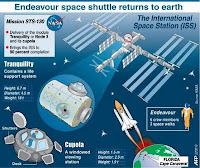 Fact file on US space shuttle Endeavour's mission to install a new model at the International Space Station. After finding a break in the rainy weather at two US landing sites, Endeavour descended to a landing in Florida to end a two-week mission that pushed the long running assembly of the International Space Station close to completion.(AFP/Graphic)
More Go To : http://news.yahoo.com/s/nm/20100222/sc_nm/us_space_shuttle_146
Special Tnx to YC5NBX for the infomations about Messages From Earth "SAIL AWAY" with LIGHTSAIL and IKAROS and "GO TO MARS" - send your name to MARS.


Participation Certificate GO TO MARS
 Artist Concept of the Mars Science Laboratory Rover
Our name will be included with others on a Microchip on the Mars Science Laboratory Rover heading to MARS in 2011.
ABOUT AMATEUR RADIO
Amateur radio service is defined in the Communication and Multimedia (Spectrum) Regulations 2000 as a radiocommunications service (covering both terrestrial and satellite) in which a station is used for the purpose of self traning, intercommunication and technical investigations carried out by authorized persons who are interested in radio technique solely with a personal aim and without any pecuniary interest.
AMATEUR RADIO OPERATOR'S CERTIFICATE
Regulation 27(1) of the Communications and Multimedia (Technical Standards) Regulations 2000 states that no person shall undertake or conduct any activity in designated skil area unless that person is certified. Amateur radio operator has been gazetted as a designated skill area category under the regulation, hence to operate an amateur radio station a person needs to have an appropriate proficiency and skill i.e. certified in this area.
INTERFERENCE
Please ensure that the radio transmision does not cause interference to any other radio services. Regulation 15(1) of the Communications and Multemedia (Technical Standards) Regulations 2000 states that no person shall intentionally design, install, operate, maintain or modify any communications equipment in a manner is likely to cause interference with, impairment, mulfunction of, or harm to any communications equipment or any other equipment.
Regulation 15(2) of the regulation denotes that a person who contravenes this regulation commits an offence and shall, on conviction, be liable to a fine not exceeding three hundred thousand ringgit (RM 300,000.00) or to imprisonment for a term of not exceeding three years or to both.
To eliminate the potential of interferences, the following procedures must be followed strictly:-
a) Ensure that suffient equipment, tools and test gear is available and can used to monitor and verify that your transmission does not cause any interference to other radio services.
b) You must responsible if your amateur radio is found to be the caused of interference. Immediate remedy action must be taken to rectify the problems in case of interference.
c) Ensure that the transmission do not exceed the level of over deviation.
d) Ensure that the radiated energy is always within the narrowest posible frequency bands for any class of emission in use.
e) The radiation of harmonics and spurious emissions should be suppressed to minimize interference.
Historical Description of Amateur Radio: From the Encyclopedia Britannica:-
Interest in amateur radio arose around the turn of the century, shortly after the Italian inventor Guglielmo Marconi successfully sent the first transatlantic wireless signal in 1901. The interference of amateur broadcasts with commercial and military transmissions led to the institution of government control in 1911. After World War I, amateurs became active in radio experimentation, contributing to developments in long-distance broadcasting and becoming the first radio operators successfully to exploit the upper medium-frequency and lower high-frequency radio bands. Over the years, amateur radio operators have also provided emergency communications during forest fires, floods, hurricanes, and other disasters. They serve as an important link between stricken communities and the outside world until normal communications are reestablished.Amateur radio operators in the United States are subject to international and federal regulations. There are five classes of licenses. Competence in the use of the International Morse Code and a knowledge of radio theory and regulation are required to obtain the advanced-level licenses. Amateur radio is allocated frequencies at the extreme high-frequency end of the medium-wave band, five groups of frequencies in the shortwave band, two groups in the veryhigh-frequency band, three in the ultrahigh-frequency band, and seven in the superhigh-frequency band for telegraphic and telephonic communication using amplitude and frequency modulation. There are restrictions on the power of the transmitters, and certain of the frequencies must be shared with due regard for the needs of other users.


 GLOBAL WARMING PR NEWS


